|
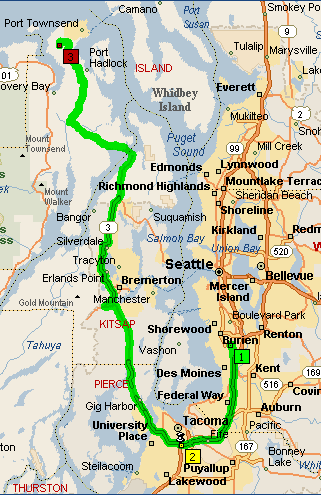
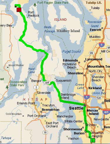
SeaTac
Airport to Port Townsend, via Tacoma
Although
you can take the Bainbridge Island ferry from the airport to
get to Port Townsend, most of the people living up here don't
do that for a some pretty good reasons. For one thing, driving
into Seattle can be a bit trying, and you often find two and
three ferry waits during the busy season. There is also the
Edmonds to Kingston ferry, the choice of our only local airport
shuttle, Pennco Transportation, when they opt to use the ferry
system instead of driving around. The ferries are relaxing and
can provide a marvelous inside view of the Puget Sound area.
The
local folks more often leave the airport and head south toward
Tacoma and get on 16 to go up the Kitsap Peninsula. Traffic
is usually better than it would be if you were headed into Seattle,
and you have a slightly shorter travel time, even if you hit
the ferry just before it leaves to cross the sound.
The
primary landmark to look for on this route is the Tacoma Dome,
which will be on your right as you are driving south on I-5.
When you see that, you will be getting really close to the exit
for Route 16.
From
there, simply follow the directions below, and you'll get to
Port Townsend without much difficulty.
| From:
Seattle-Tacoma International Airport To: Port
Townsend |
| Time:
Generally a bit less than 2.5 hours |
|
Directions
|
| Depart
Seattle-Tacoma International Airport on Local road(s) (East)
for 54 yds |
| Bear
RIGHT (South) onto Ticketing/Check In [Check In Dr] for
0.3 mi |
| Bear
LEFT (North-East) onto Terminal/Parking/Rental Car Return
Acc [North Exit DR] for 0.3 MI |
| Continue
(North) on North Exit DR for 1.3 MI |
| Bear
LEFT (North) onto Ramp for 0.6 MI |
| Merge
onto SR-518 (West) for 1.3 MI |
| Turn
off onto Ramp for 0.4 MI |
| Merge
onto SR-509 (North) for 4.7 MI |
| Continue
(North) on SR-99 [SR-509] for 1.9 MI |
| Bear
LEFT (North) onto E Marginal Way S for 1.4 MI |
| Continue
(North) on Alaskan Way S for 1.1 MI |
| Bear
LEFT (West) onto Yesler Way for 0.1 MI |
| Continue
(West) on Marion St for 10 yds |
| *Check
timetable* Take Seattle-Bainbridge Island Ferry (West) |
| Take
Olympic DR SE (North-West) for 0.3 MI |
| Bear
RIGHT (North) onto SR-305 [SR-305 NE] for 13.2 MI |
| Turn
off onto Ramp for 0.3 MI |
| Merge
onto SR-3 (North) for 6.8 MI |
| Turn
LEFT (Northwest) onto SR-104 for 11.1 MI |
| Turn
RIGHT (East) onto Center Rd for 6.8 MI |
| Turn
RIGHT (East) onto SR-19 until it merges with SR-20 |
| Bear
RIGHT (East) onto SR-20, and follow it into Port Townsend |
SeaTac
Airport to Port Townsend via Ferry
If
you still really want to ride the ferry to Bainbridge Island,
this is how to get there from the airport...or you can travel
farther up Rt. 5 and cross from Edmonds to Kingston. A link
to ferry information and schedules is provided for your convenience.
Washington
State Ferries
| From:
Seattle-Tacoma International Airport To: Port
Townsend |
|
Time: Variable, depending on ferry times and waiting
lines. |
|
Directions
|
| Depart
Seattle-Tacoma International Airport on Local road(s) (East)
for 54 yds |
| Bear
RIGHT (South) onto Ticketing/Check In [Check In DR] for
0.3 MI |
| Bear
LEFT (Northeast) onto Terminal/Parking/Rental Car Return
Acc [North Exit DR] for 0.3 MI |
| Bear
LEFT (North) onto Parking/Rental Car Ret/Bag Claim [Pick
Up Return DR] for 142 yds |
| Bear
LEFT (West) onto Parking/Baggage Claim [Pick Up Return DR]
for 32 yds |
| Bear
LEFT (Southwest) onto Parking/Baggage Claim [Pick Up DR]
for 0.4 MI |
| Continue
(South-East) on South Exit DR for 0.1 MI |
| Bear
RIGHT (South) onto SR-99 [International Blvd] for 1.2 MI |
| Turn
LEFT (East) onto S 200th St for 0.4 MI |
| Bear
RIGHT (Southeast) onto Ramp for 0.2 MI |
| Merge
onto I-5 (South) for 18.5 MI |
| At
I-5 Exit 132, turn off onto Ramp for 0.4 MI |
| Merge
onto SR-16 (West) for 26.7 MI |
| Continue
(North) on SR-3 [WA-3 W] for 25.4 MI |
| Turn
LEFT (Northwest) onto SR-104 for 11.1 MI |
| Turn
RIGHT (East) onto SR-19 until it merges with SR-20 |
| Bear
RIGHT (East) onto SR-20, and follow it into Port Townsend |
Final
approach to the door from the south (Cimacum)
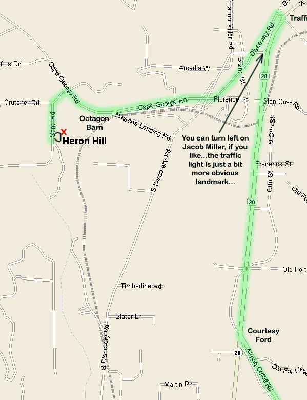
|
Directions
|
| Stay
on Route 19, headed toward Port Townsend. |
| Go
past the Jefferson County International Airport. Route
19 joins Route 20 at the traffic light on the corner next
to the Courtesy Ford dealership. |
| Stay
on Route 20 toward Port Townsend. |
| Continue
to the next traffic light. (The Frugal Framer is on the
left and a Honda lawn mower and cycle shop is on the right
side of this intersection.) |
| Turn
left at this light. The street ends in less than 50 feet
in a T intersection. Turn left at this T, onto Old Discovery
Road. |
| Stay
on Old Discovery until you come to Cape George Road. |
| Turn
right onto Cape George Road. |
| You
will pass a small octagon barn and horse pasture on the
left side of the road. This is your landmark to begin
looking for Crutcher Road. |
| Crutcher
Road is the next left. The green sign for it is on the
right side of the road you are on. There's a row of mailboxes
at the beginning of Crutcher Road. |
| Turn
left onto Crutcher Road. |
| The
first left is Sand Road (brown sign)...turn onto Sand
Road. |
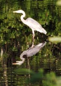
| The
driveway for Heron Hill is the first left on Sand Road.
There's a short section of white picket fence, and a red
number plate with "241" printed on it. There
are also signs with the Northwest Heron, flying in the
direction you need to go. |
| Since
this is a one way loop driveway, please drive counterclockwise
on it, just to make sure you won't meet someone coming
the other way. |
| Drive
to the top of the hill and you've arrived! |
|